May 1, 2015
El Gardood: the Gulf tableland
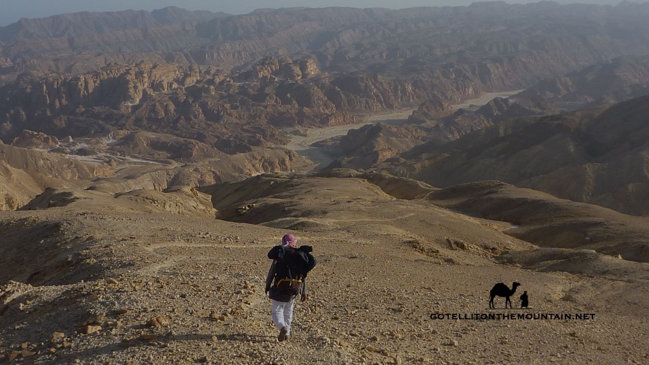
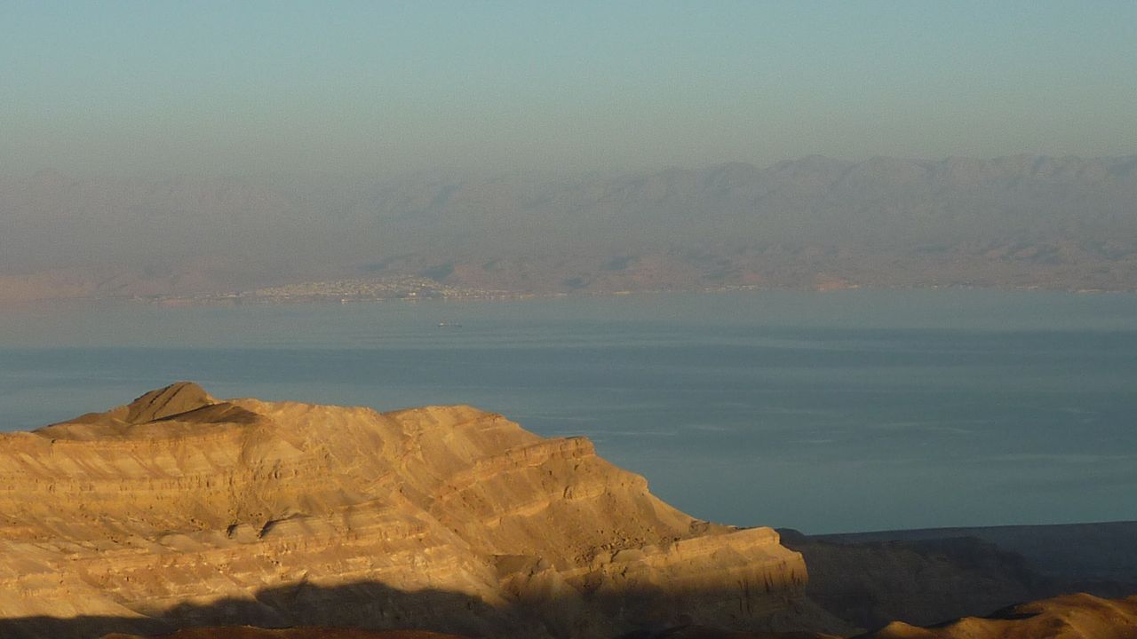 Walk inland from the Gulf of Aqaba coast – anywhere between Ras Shetan and Taba – and you’ll enter chain after chain of rugged coastal mountains. Carry on – following the wadis that snake between these mountains – and you’ll soon reach the bottom of a gigantic cliff: a huge natural foritification to the Sinai’s beautiful desert interior. Getting up it isn’t easy. Everything’s loose. There are big drops in places. If you hold your nerve and climb it though, you’ll emerge on one of the Sinai’s great natural wonders. A high desert plateau where you can gaze over the Gulf of Aqaba – the watery ribbon of blue – to the Hejaz mountains of Arabia. You can see cities like Hagl in Saudi Arabia and Aqaba in Jordan. Ocean liners look like tiny dots, never moving on the waves.
I’d been to the bottom of this plateau before. But I’d never gone up. I’d never heard anyone talk about it either. Not until a maverick Bedouin friend called Musallem called me a couple of months ago anyway, saying we should make a route over it for a new trail called the Abraham Path.
If you haven’t heard about the Abraham Path check it out HERE. It’s a new long-distance walking trail in the Middle East, lately voted the No. 1 trail in the world by National Geographic. The aim is to develop sustainable economies for local people, boost adventure tourism in part of the world that gets more bad press than any other, and get people walking, talking, and understanding the region better. It’s the most ambitious hiking project ever started in the Middle East and will be a major milestone for the region when it’s finished.
Musallem and me have been helping here and there with the Sinai part. Last year we nailed down a 200km route from Ras Shetan to St Katherine. By doing this plateau, he reckoned we could add an extra 30km too, opening up a new trekking area in the Sinai and spreading the benefits to more communities.
 As it turned out, Musallem had been up here before. Actually he’s been pretty much everywhere in the Sinai. At least in the desert. He goes to the places where virtually nobody else ever goes. Because they’re there. Which is one of the reasons I like him so much. He hadn’t just walked this plateau either. He’d ridden a mountain bike over it (probably the first person in history ever to even think of riding a mountain bike across it). Anyway, we arranged to do it, finding a hiking route that’d cross the plateau and connect to the route we already had further south. The first time we did it, we drove inland from the coast, circling round to the interior side of the plateau, where it’s easier to get up.
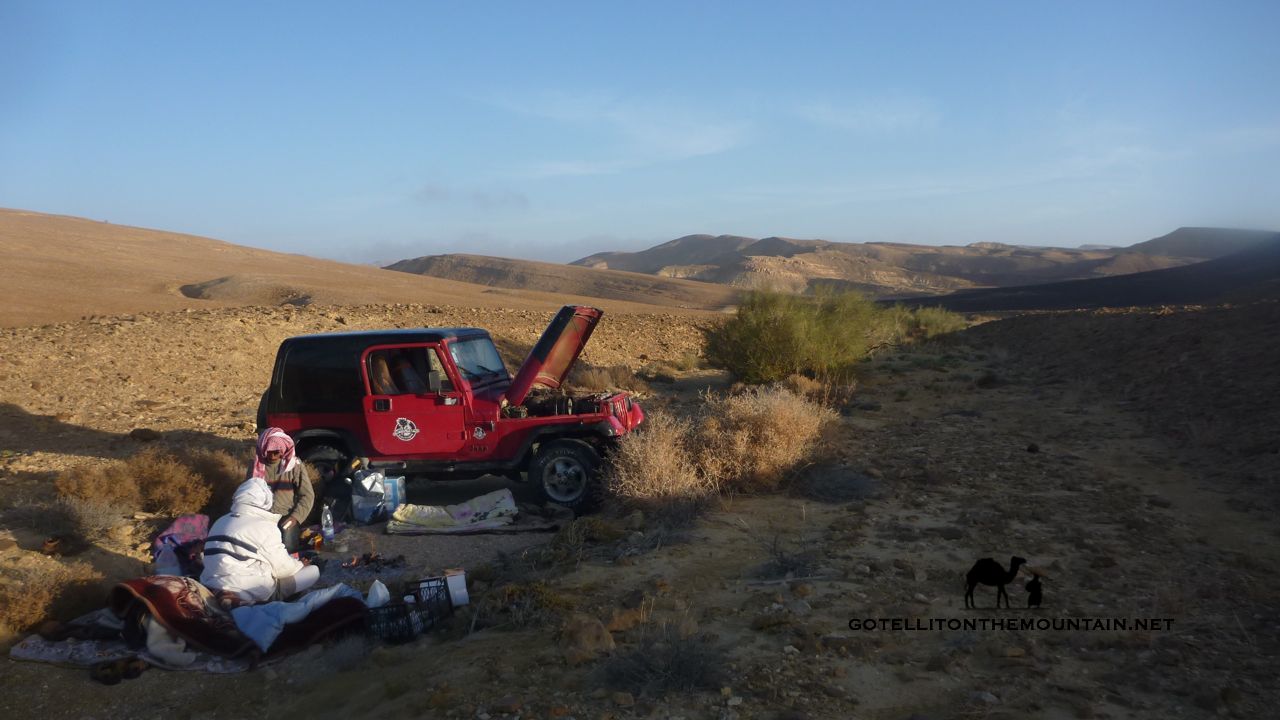
A strong wind blows over the edge of this plateau at night, rushing down to the sea. It’s nearly 1000m in altitude too, which makes it extra cold. We slept up here, waking to see frost clinging to the retem bushes and our sleeping bags wet with dew. We huddled over the fire, warming our hands before leaving the jeep behind and heading south on foot, mapping the trail.
When most people think of mountains in the Sinai, they think of Mount Sinai: a dramatic granite highlands type of landscape with bulging bronze cliffs and smooth whaleback summits. When it comes to the mountains of the Sinai, plateaulands like this are much more common though.
As mountains, or highlands, or whatever we should call them though, they cover more of the peninsula in area size. And they’re almost as high as some of those peaks of the Mount Sinai area too. Some are nearly 1500m high.
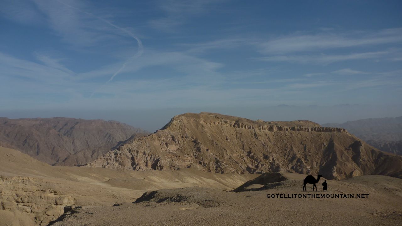 Of all these plateualand mountains the most popular with trekkers is one called Jebel el Gunna. The most famous is Hadabat el Teeh: the Biblical Wilderness of the Wanderings where legend has it Moses walked for 40 years. El Gardood – as they call this plateau along the Gulf – is the most little known of these highlands. For what it’s worth (and as someone who’s walked all of these highland plateaus) I reckon it deserves much more attention than it gets though. Whatever merits the other plateaus have, standing up here and looking over the Gulf to the Arabian Peninsula is one of the Sinai’s great views. Gazing down over the sea and looking at four countries at once makes it feel like you’re standing on a gigantic map of the Middle East. It’s all there, spread out before you.
We took a whole day finding our way across the plateau that day, walking 28km through deserted basins and rugged passes until we got to its southerly edge. This was exactly where we needed to be to connect this new trail to the southerly one we’d already put down the year before. And a good path ran all the way down.
The next week – gluttons for punishment that we are – we went back to do the whole thing again, only this time with someone from the Abraham Path. And this time, there was no cheating with a jeep. We needed to find a way up onto the plateau from the sea – and a way through its foreboding cliffs – which we finally did. Actually, there are a couple of old trails; or rather, remnants of old trails. They have been damaged by repeated flash floods over the years so they’re tricky.
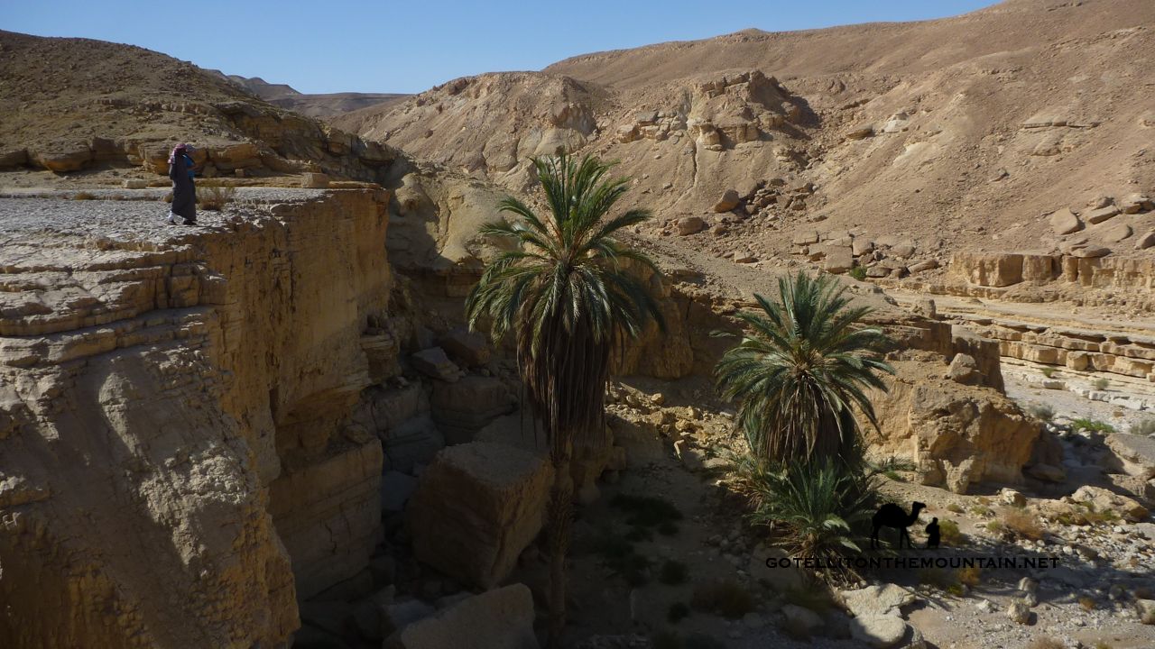 Up on the top, walking on the flats, we took the same route over the plateau as the first time. This time though – taking notes and making route guides – we took our time with everything. We also explored a few new areas of the plateau. One of the best spots we saw was an oasis called Ein el Shefalla; just a few palms below a high cliff, but a real beauty of a spot. Nearby – where the water plunges from the high cliff into the sands after rain – is a dry hole where you can dig to get water. The Bedouin call a hole like this a themila. Start digging and after a while, you’ll smell the water, seeping through the sand. Soon, the water seeps into the hole, which you can scoop up. Or sponge it in a shemagh.
The more I walked up on El Gardood the more I liked it. It’s different to the Sinai’s other plateaus. Grander, with massive highland chunks. Its wadis are deeper. And greener. Everywhere feels much lesser trodden. There are no footprints. No litter. It’s easy to find firewood, because so few people ever use it.
It’s also like a window back to the more ancient times.
Look carefully and you’ll find blackened fireplaces and stones marking out Bedouin sitting places. There are old cemeteries with graves pointing towards Mecca and old storerooms in the cliffs. Once upon a time, El Gardood was where the Bedouin came to graze their flocks in the springtime.
 That second time on El Gardood we walked all the way out: down from the plateau, into the the sandstone desert, then out of the coastal chains to Ras Shetan. Everything said, it was mission accomplished: we’d connected the two trails. The guys at the Abraham Path are busy developing trail guides right now – along with lots of other great stuff – and I’ll update the blog when they’re ready. Look out for the trail as it’s going to be great. If you want to do El Gardood before the trail’s finished, you can. There’s a lot to explore and discover. Just be sure to go with a good Bedouin guide: my tried and tested tip is Mussalem. Take it all in and remember it too. Because once places like this get discovered and put on the map, they don’t stay secret for long…
Check out this Google Map I made of the rough area of El Gardood.